


Hawai
North-America Posted by gaytravel on Wed, Mar 21st, 2018 @ 7:51:11 PM 232 0
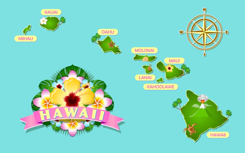
Hawaii is the 50th state of America. It is also the most recent state to have joined The US and got state head since 1959. It is a group of islands in the Pacific belonging to Oceania. The islands composing Hawaii are: Ni’ihau, Kaua’i, O’ahu, Moloka’i, Lāna’i, Kaho’olawe, Maui, and the Island of Hawai’i.
Ni’ihau, privately owned island of the Hawaii group

Aerial view of Niihau, Hawaii – © Polihale at English Wikipedia [GFDL or CC BY-SA 3.0], via Wikimedia Commons
This era marked the end of the art of Hawaiian matting, made famous by the people of Ni’ihau. Makaloa (Cyperus laevigatus), a native sedge, grew on the edges of Ni’ihau’s three intermittent lakes. The stems were harvested and used to weave moena makaloa (mats), considered the “best sleeping mats in Polynesia”. The mats were appreciated by both ali’i and foreign visitors, but by the end of the 19th century, Hawaiians had stopped weaving makaloa as a result of changes in population, culture, economy and the environment.
In 1915, Sinclair’s grandson Aubrey Robinson closed the island to most visitors. Even relatives of the inhabitants could visit only by special permission. Upon Aubrey’s death in 1939 the island passed to his son Aylmer, and in 1968 to Aylmer’s youngest brother Lester. Upon Lester’s wife Helen’s death, the island passed to his sons Bruce Robinson and Keith Robinson, the current co-owners.
Ni’ihau played a small role during the attack on Pearl Harbor on December 7, 1941. In what has come to be called the Ni’ihau Incident (or the Battle of Ni’ihau), a Japanese pilot whose Zero had been hit crash-landed on the island hoping to rendezvous with a rescue submarine. The pilot escaped with the assistance of local Japanese residents, but was later recaptured and killed. It was the subject of a popular song, “You Can’t Conquer Niihau, Nohow”.
Despite its self-imposed isolation, Ni’ihau has a long-standing relationship with the U.S. military dating from 1924. There is a small Navy installation on the island. No military personnel are permanently stationed there, but the U.S. military has used the island for training special operations units, which included hiring Hawaiians who live on Ni’ihau as “enemy” trackers.
Beginning in 1987, a limited number of supervised activity tours and hunting safaris have opened to tourists. The island is currently managed by brothers Bruce Robinson and Keith Robinson.
The 2010 census states that there were 170 people living on the island.[28] However, witness accounts estimate that the population actually ranges between 35-50 people.[29][30] Some support themselves largely by subsistence fishing and farming, while others depend on welfare.[31] All residents live rent-free, and meat is free. Niʻihau has no telephone services and no paved roads. Horses are the main form of transportation; bicycles are also used. There are no power lines; solar power provides all electricity. There is no plumbing or running water on the island. Water comes from rainwater catchment. The Robinson family established most of these conditions. There is no hotel, and barges deliver groceries from Kaua’i, often purchased by relatives, with free shipping.
Residents generally speak the Niihau dialect of Hawaiian as their first language, in part encouraged by terms in the original purchase contract which obligated the new owners to help preserve Hawaiian culture and tradition. English is the second language.
Some residents have radio and television sets, although limited reception effectively limits the latter to watching VHS tapes and DVDs. Niʻihau is subject to regular droughts that occasionally force the population to evacuate to Kauaʻi temporarily, until rainfall replenishes their water supply. Residents commonly also commute to Kauaʻi for work, medical care, or school, and many of them call both islands home. To avoid a long boat ride, the island’s owners maintain an Agusta A109 helicopter for emergencies and for transporting Navy contractors and residents to and from Kauaʻi. Helicopter tours and safaris help offset the costs of this service.
The Hawaii Department of Education operates the Niʻihau School, a K-12 school. Academic subjects and computer literacy are combined with teaching students to “thrive from the land.”[9] The school is powered entirely by solar power.[38] The number of students varies from 25 to 50 since families often travel between Niʻihau and Kauaʻi.[39] Schoolchildren may stay with relatives in west Kauaʻi, where they attend one of two Niʻihau-focused public charter schools. At the Ke Kula Niʻihau o Kekaha school, students speak primarily the Niʻihau dialect through the early elementary grades, and then Hawaiian and English through grade 12. The school has a digital recording and video system, which helps to preserve and teach traditional Niʻihau and Hawaiian culture.
Economy
Approximately 80% of Niʻihau’s income comes from a small Navy installation atop 1,300-foot-high cliffs. Remote-controlled tracking devices are used for testing and training with Kaua’i’s Pacific Missile Range Facility. Modern missile defense tests are conducted at the site for the U.S. and its allies. The installation brings in millions of dollars a year, and provides the island with a stable economic base without the complexity of tourism or industrial development.[9] The sale of shells and shell jewelry is an additional source of income.[40] Its beaches are known for their pūpū, tiny shells that wash onto shore during winter months. Species used for shell leis includes momi (Euplica varians), laiki or rice shells (Mitrella margarita) and kahelelani (Leptothyra verruca).[41] The shells and jewelry are so popular that Governor Linda Lingle signed a bill in 2004 to protect lei pūpū o Niʻihau (Niʻihau shell leis) from counterfeiting.[42] A single, intricate Niʻihau shell lei can sell for thousands of dollars.[9]
Trash deposited by the ocean on a windward Niʻihau beach
Many residents of Niʻihau were once employees of Niʻihau Ranch, farming cattle and sheep until the Robinsons shut down the operation in 1999. It had not been profitable for most of the 20th century.[citation needed] Honey cultivation[43] was also no longer viable by 1999.[22] Kiawe charcoal was once a large-scale export, but aggressive Mexican price competition ended that as well.[9] Mullet farming has been popular on Niʻihau, with ponds and lakes stocked with baby mullet, which reach 9–10 pounds (4.1–4.5 kg) apiece before being harvested and sold on Kauaʻi and Oʻahu.[44]
Bruce Robinson, Niʻihau’s co-owner, is seeking and considering new forms of non-invasive income generation. Depending on feasibility, impact, and ecological footprint on the ecosystem and culture, possibilities include: JP-8 generation by the lignocellulose process; military, including a possible runway; and windmill energy production. Robinson has declined offers to purchase sand from Niʻihau’s beaches, because of adverse environmental effects.[9]
Tourism
Niʻihau’s owners have offered half-day helicopter and beach tours of the island since 1987,[45] although contact with residents is avoided and no accommodations exist.[46] Since 1992,[47] hunting safaris provide income via tourists who pay to visit the island to hunt eland, aoudad, and oryx, as well as wild sheep and boars. Any meat the hunters do not take with them is given to the village.
Kaua’i

Kauaii, Hawaii
O’ahu

Hawaii, Oahu
Nickname: The Gathering Place
Oahu (1).jpg
Satellite photo of Oahu
Map of Hawaii highlighting Oahu.svg
Geography
Location 21°28′N 157°59′W
Area 596.7 sq mi (1,545 km2)
Highest elevation 4,003 ft (1,220.1 m)
Highest point Ka’ala
Administration
United States
Symbols
Flower ʻilima
Color Melemele (yellow)
Largest settlement Honolulu
Demographics
Population 976,372 (2012)
Pop. density 1,636 /sq mi (631.7 /km2)
Aerial view of Oahu with freeways and highways, 3D computer-generated image
File:Oahu, Hawai’i.ogv
Fly-around tour of the island
O‘ahu (pronounced [oˈʔɐhu], anglicized Oahu /oʊˈɑːhuː/) known as “The Gathering Place” is the third largest of the Hawaiian Islands. It is home to about two-thirds of the population of the U.S. state of Hawaii. The state capital, Honolulu, is on Oahu’s southeast coast. Including small associated islands such as Ford Island and the islands in Kāneohe Bay and off the eastern (windward) coast, its area is 596.7 square miles (1,545.4 km2), making it the 20th largest island in the United States.[1]
Oahu is 44 miles (71 km) long and 30 miles (48 km) across. Its shoreline is 227 miles (365 km) long. The island is composed of two separate shield volcanoes: the Waianae and Koolau Ranges, with a broad “valley” or saddle (the central Oahu Plain) between them. The highest point is Ka’ala in the Waianae Range, rising to 4,003 feet (1,220 m) above sea level.[2]
Pearl Harbour
Tourism
Beaches
Top beaches
Ala Moana Beach
Hanauma Bay
Kāneohe Bay
Ko Olina Beach Park
Kailua
Lanikai Beach
Sandy Beach
Sunset Beach
Waikīkī Beach
Waimanalo Beach
Waimea Bay
Ala Moana
Aloha Tower
Aulani, a Disney Resort & Spa
Banzai Pipeline
Bishop Museum
Diamond Head
Dole Plantation
Foster Botanical Garden
Kaena Point
Honolulu
Honolulu Museum of Art
Hoʻomaluhia Botanical Garden
ʻIolani Palace
Kualoa Ranch
Lāʻie Hawaii Temple
Nuuanu Pali Lookout
Mauna Ala
Makapuu Lighthouse
National Memorial Cemetery of the Pacific or “Punchbowl”
North Shore
Pali Lookout
Pearl Harbor
Polynesian Cultural Center
Triple Crown of Surfing
USS Arizona Memorial
USS Missouri
Valley of the Temples Memorial Park
Waikīkī
Waikiki Aquarium
Waimea Valley Audubon Center
Waimea Valley
Moloka’i

Halawa Valley, Molokai, Hawaii – © Rose_Braverman [CC BY 3.0], via Wikimedia Commons
Lāna’i

Garden of the Gods Lanai, Hawaii
Kaho’olawe

Kahoolawe, Honokanaia, Hawaii © Forest & Kim Starr [CC BY 3.0], via Wikimedia Commons
Maui

Maui, beach resort, Hawaii
the Island of Hawai’i

Pāhoehoe and Aa flows at Hawaii island, Hawaii – © Brocken Inaglory (Own work) [GFDL or CC BY-SA 3.0], via Wikimedia Commons
Kohala coast at the Big Island of Hawaii, Hawaii – © George (Own work) [CC BY-SA 3.0 (https://creativecommons.org/licenses/by-sa/3.0) or GFDL (http://www.gnu.org/copyleft/fdl.html)], via Wikimedia Commons

What is NEXXTRIP?
NEXXTRIP is a travel site with flight search engine based upon AVIASALES. Except for flights it also offers hotels and holidays packs from different travel agents. NEXXTRIP also has gay travel and a business directory.
NEXXTRIP - trusted by 100 000 + regular travelers


MDB free download

